Showing posts with label hiking. Show all posts

Tuesday, July 2, 2013

The oppressive heat is no excuse to weasel your way out of exercising!

Get on the trail and stop making excuses. Drink plenty of water, and eat a couple of bananas. Take at least an additional liter of water per person. Today, I decided to tackle Griffith Park from the Western end of Ferndell. Just walk a couple of hundred yards past the kid's playground and keep to the left. There are several ways to speed this section up the best was is to just start running slowly and bear right past the sycamores to a little trail that will take you straight up the ridge and finish up at those picnic tables just below the road. Cross the street, and head up the hill and soon you will be at the bridge. Keep on going up, breathe through your nose and exhale through your mouth. Keep hydrated. Take a look at the panoramic views and the inevitable pair of raven soaring overhead.
Once you get to the top take a look around and start heading down at once Pick up the pace a little bit and scan the trail ten feet in front of you. Let gravity carry you down the hill, and do not stop. Breathe and keep hydrated. Run at 3/4 speed until you get to the picnic area. Stretch for at least 15 minutes before heading to your car. Face it, it must have taken you a couple of years to get into bad shape, and it will probably take you at least a year to start seeing good results. You have to eat whole foods also! Working out alone is not enough. It is a lot of work. If you want to keep fit, you are going to need to do this run at least five days a week pushing yourself each and every time. You can go in the morning, or in the evening, it does not matter as long as you do it. It does not get easier, ever. Park your car across Los Feliz Blvd. so you don't get a parking ticket, and so that you don't cut any corners like a cheating bastard. There is another way to get a really good workout and that is by going up the steep hill to the right of the ever popular fire road leading up to the Observatory out of Ferndell. Run up this hill if you want to work your body the fuck out and fill each and every cell in your body with rich oxygen and nutrients. When you get to the top of the first steep hill, run like hell down the slope until you can barely take it anymore. Try to make yourself run up the next hill. Then the next one. And so on. After running this trail every day, I feel like 98% of my problems have been solved. I feel great, and look 10 years younger. Trail running even makes my hair grow back in a lush and shiny manner. I suspect that you will probably get the same results. I did it, and you can, too!

Monday, July 1, 2013

Kasha Katuwe Tent Rocks National Monument

There is a reason why New Mexico is called the Land of Enchantment and clearly it is places like this. Just take a little extra time to get out here and hike up to the top of the Slot Canyon Trail to check out one of the best views I have ever seen in my life. The canyon itself is pretty narrow, and when we came up was completely filled with snow. The scenery, as you can see from the pictures is unforgettable. When you get to the top, the reward becomes quickly evident when you catch your first panoramic glimpse of the valley. Spectacular!

Crystal Cove State Park

I have never felt welcome in Orange County. Not for one moment. OC is the birthplace of punk rock music, and there are some great Vietnamese restaurants, but I'll voluntarily stay on my side of the curtain. I do like Crystal Cove, however. One cannot wonder what this place must have looked like before someone got the bright idea to litter the landscape with a golf course and faux-talian mansion monstrosities. Fortunately this little strip of the Orange Coast and a few thousand acres of behind the beach are protected and a great campground with million dollar sunset views is available to the general public. There are sites with all of the amenities (showers, water, tables) down by the beach, and a couple of dozen sites with fewer features if you are willing to hike 3 to four miles into the backcountry with all of your gear, water and food. There will be nobody camping in the backcountry, so if you are looking for solitary experience you are going to find it here at this time of the year at night (during the day the trails are swarming with people). Several trails go into the backcountry and if you decide to walk along the park boundaries it is about 11 miles. It took us a little over two hours to make the loop, and was stunning. It is not really a trail, it is more like a fire road. It is evident that they maintain this place very well. There is a lot of costal sage, and oaks at the bottom of the canyon. Red tailed hawks, turkey vultures, robins, and beautiful black ravens are abundant in the park. This time of the year, the canyons were green and lush and there were plenty of wildflowers. The rodent population seemed pretty healthy as well. You cannot access the beach from the campground. It requires a short walk up PCH. There are no campfires or bbqs allowed anywhere in the park. A Trader Joes is located less than a mile away and there are plenty of dining options in the area. This park is one of Orange County's crown jewels.

Mt. Lowe

Before the Station Fire, Mt. Lowe was one of the most beautiful areas in the local mountains. Those were the days. It was like a little corner of the Sierras about a half hour from Downtown Los Angeles. There are a number of trails leading to the top of Mt. Lowe. If you are interested in the scenic route, begin at the Cobb Estate/Lower Sam Merrill, continue on the Castle Canyon trail to Inspiration Point, then to the Campground and finally the summit. In the alternative, go up Angeles Crest Highway, turn right on Mt. Wilson Road and park your car at Mt. Lowe Saddle 2.1 miles up. This is the way to go if you are not an avid hiker or are with small children. From the saddle, walk through the beautiful CCC Era Stone Tunnel and take the East Trail to the Mt. Lowe summit. It is a suitable trail for children and dogs are permitted. The area used to be home to some nice oaks but since they burned, a bunch of Poodle Dog Brush and chaparral have popped up. The rock formations with the burned trees sticking out and the backdrop of the blue sky and the green meadow below are sublime. Wildflowers with beautiful shades of red are abundant at this time of the year. From the top of Mt. Lowe, there are some nice views of the Los Angeles Basin and Mt. San Antonio and San Gorgonio to the east. You will probably see Raven or Red-Tailed Hawk.

Sunday, June 30, 2013

Ice House Canyon Trail

The other day, I took the Chapman Trail, which was entirely new to me. You have to walk up the Ice House Canyon Trail for approximately a mile, and then you will see it on the left hand side marked by a sign. I found it to be almost empty, in contrast to the dozens, if not hundreds of people on the Ice House Canyon Trail to the South. The Chapman Trail offers some beautiful scenery as you traverse moderate switchbacks through chaparral, oak, cedar groves, unspoiled meadows, towering yucca with giant white flowers across a background of blue sky. Eventually winding up at Ice House Saddle, I can hardly wait to go back here. In fact, I think I will tell them I am sick later this afternoon so I can get out of the office and back on that trail. Healthy rodent population, trees look green and healthy for the most part, plenty of birds but I didn't see any raptors at all. You are going to arrive at the wilderness boundary at the 3 mile mark, after which you will need a permit(Baldy Ranger Station). Get an adventure pass to park(Big5). This is a really sacred place, and whatever little words I put on the internet don't do it much justice. Spring is an absolutely stellar time to come out to either of these trails. The scenery includes red, white, pink, blue and purple wildflowers, a billion shades of green, endless blue skies, all backed up with a chorus of that babbling brook off to the side of the trail. There is some damage here caused by the bark beetle, but it is not too extensive. When I arrived yesterday, the parking lot was full, but I had no problem getting a permit from the Ranger Station and made it to the top in a leisurely two hours. When you get to the top of the saddle, there are several other trails to continue on if you so desire. I posted some photos so you could see what I am talking about. 
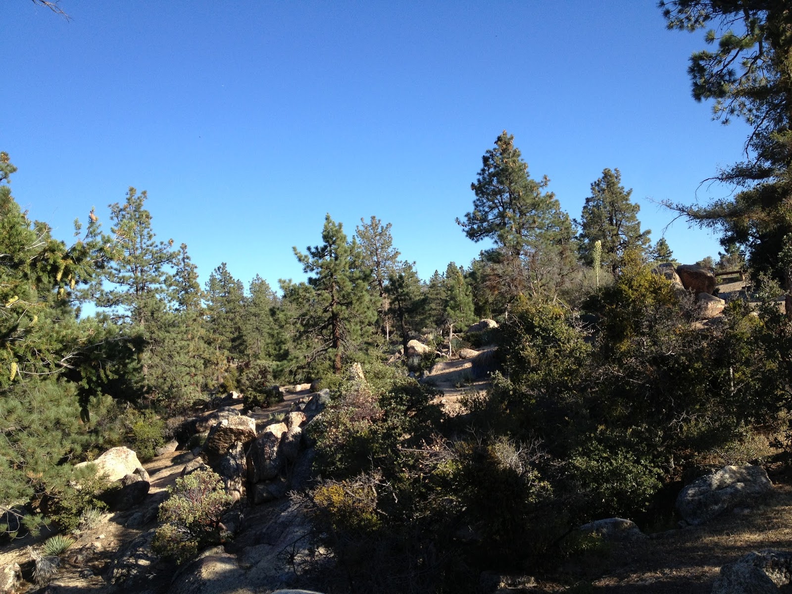
The trail goes uphill for about 4 miles, following a creek for the first half of the hike. There are several areas where the freezing cold water is deep enough to take a swim and several places where you could just spend the whole day taking in the greenery and the scenery with a picnic basket. There is a lot of shade, but you will still need some sunscreen. You are going to see a ton of squirrels, birds, and chipmunks on this trail. There are also bear and deer so if you decide to camp here, get a bear can and don't bring chapstick or lotion into your tent. You are also going to see a ton of people, but nothing compared to the trails in Griffith Park or Runyon Canyon and the flash mobs that suddenly appear there at 7AM. The Cucamonga Wilderness which you pass through about midway up the trail is stunning. These mountains are majestic and almost impassable. You are going to belvedere yourself when you see the views as you are climbing through this wilderness. You need a wilderness permit to hike past this boundary and can obtain it at the ranger station. Keep in mind they are not open every day. Call in advance. As you get towards the saddle, the trail narrows a bit, and the chutes are probably a hundred feet down or so. Tell your children to be careful here.
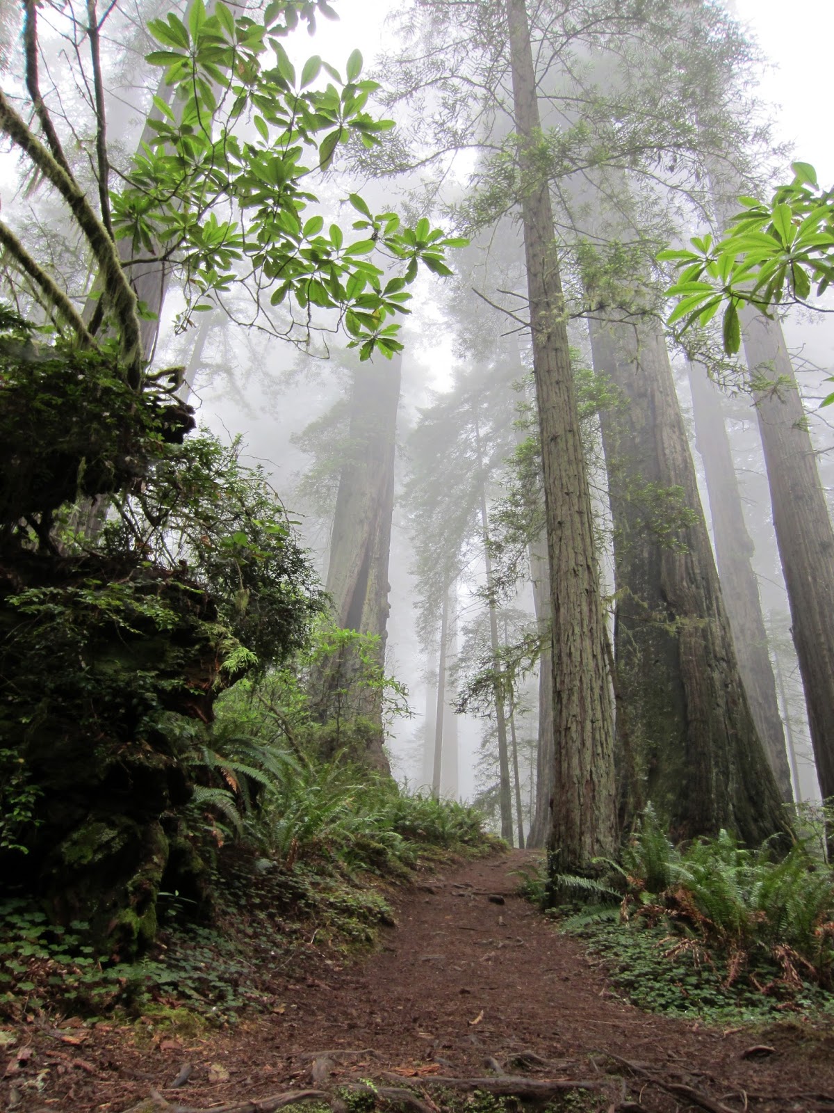
Inspiration Point Via Castle Canyon

could not wait to come back here, so I picked the hottest day of the Summer so far, and let me tell you folks, this trail is a real ass kicker! If you are jogging, you are probably burning around 800 calories an hour so make sure to have eaten plenty of rice or steamed potatoes the night before you set out. Drink a shitload of water before, too! There was not much traffic on the trail at all. I saw a few nice folks on the Sam Merrill Trail on the way up, but there was not another human soul in Castle Canyon yesterday afternoon. If you ever want to get connected with the spirit of Summer, then you could do a lot worse than this trail. It is hot and just keeps getting hotter. The rocks are like charcoal briquettes and just toasted me yesterday. There was no shade at all. The last time

Del Norte Coast Redwoods State Park

This is a big park with a couple of camping options and a hundred miles of trail. There are some huge old growth trees and some scenery that you will never forget. But you already knew that. I suggest the Damnation Creek Trail located at mile marker 16 off Hwy 101 four miles south of the Mill Creek Campground. It is an old Yurok trail that will take you approximately two miles down a moderately steep path to the beach where you will pass some of the most magnificent old growth trees you will ever see. It must have been too steep to remove the lumber, so these giants lives were thankfully spared. The way that the sunlight shines through the fog and filters through the trees here will leave you speechless. There are some amazing colors in this forest! The beach is equally awesome. The Hobbs Wall trail to the Mill Creek Trail is another nice trail that is accessible from Mill Creek Campground located within the park. The trail will take you to some nice sections of the park. It is about 8 miles up and back with plenty of water that you could drink after filtering. My wife and I did not see one other human soul on this trail. Mill Creek Campground is relatively uncrowded, covered in second growth trees and has some of the most awesome campsites I have ever encountered anywhere. Bear, deer, raven, banana slug, and stellar jay will be on the trail. Campsite #90 is especially nice.
It is a wonderful place to camp when you are exploring this park.

Patrick's Point State Park

Patrick's Point State Park This park is one of the crown jewels of California's State Park System. It is a seldom used place open year round overlooking Agate and Trinidad State Beaches with jaw-dropping views of the North Coast. The mixed forest within the park is filled with crows, jays, ravens, mountain lion, brown bear, chipmunk, deer, elk and other creatures. Keep your food locked in the bear box and take all the soap and candy out of your car or face the consequences. The Rim Trail is just a few miles long and will take you along a beautiful path where the forest meets the ocean and a couple of paths lead down to the water. The campsites here are huge and private and you are going to have a couple of areas to choose from. The Agate Beach Trail is currently closed, however. At the time of our visit, the fog had burned off by around 2PM offering some astounding scenery from the Rim Trail and the top of Ceremony Rock. Light pollution is relatively low here on the point and looking at the stars here with the sound of the ocean in the background makes life worth celebrating. All campsites in this and every other California State Park are $35.00 a night. A generous two (2) dollar discount is available for seniors. If you hike or bike into the campground, the cost is $5.00 per person.

Brand Park Hiking Trails

Brand Park is situated in the Verdugo Mountains in the foothills of Glendale. For the hike to the top, start at the fire road behind the doctor's house and walk about a mile up past the landfill. Turn left about 50 yards ahead when you get to the large sycamore tree for the steeper trail. The more challenging side has a set of radio towers on top and ends at the top of Tongva Peak. It may help some people to wear cleats to get a better grip, but I have no problems using trail running shoes. This trail has a good elevation gain, but is a relatively short hike. If you run down the fire road to the west of Tongva Peak, your return trip will total 4.1 miles to the parking lot. This approach is steep and challenging. There is another trail that goes to the top east of here. It is significantly easier, but still difficult. It has a nice place to rest at the halfway point. It takes my wife and I 1 hour and 10 minutes to go up and back on the more difficult trail running briskly most of the way. Things to take into account: There is no shade There are little gnats, flies and hornets so use DEET There is no water Like any hike, you can slip and fall and crack your head open and perish and the plants and animals don't care so just enjoy yourselves and don't take any unnecessary risks. 
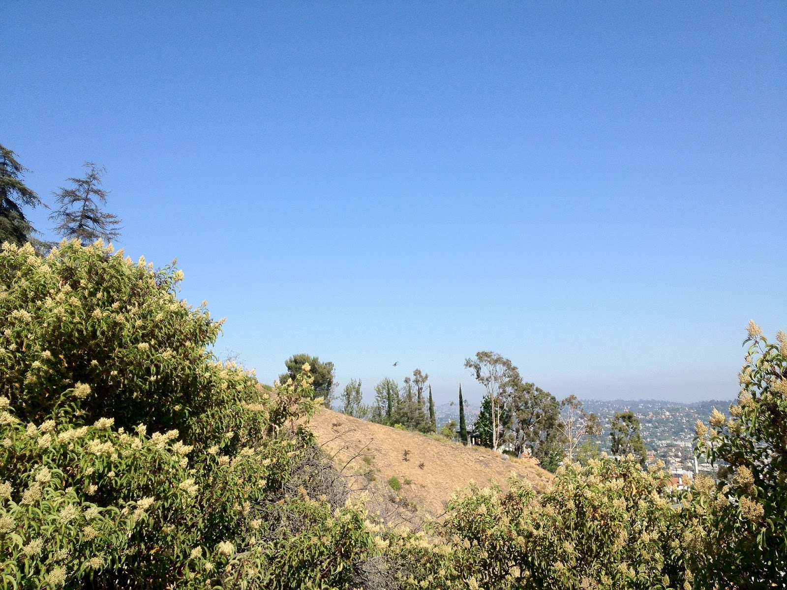
Superior views on clear days of the San Gabriel Mountains on one side, and the sprawl on the other Rabbit, squirrel, coyote, and a bobcat or two. A couple of nice oaks. Some sycamore and pine. This park is filled with cool stuff in general. There is a branch of the Glendale public library but you probably knew that. The Brand Park Arts Library is not like your ordinary inner city library branch. It does not get crowded with screaming, hyperactive brats wheedling away on the internet and smearing their filthy germs all over the keyboards. For sure, it is the crown jewel in their system. It sure has a lot of very cool art books and non-book materials. It is almost like a miniature version of the Arts Library at UCLA, but with free parking and a considerably more delightful setting. The Brand Family graveyard is on the premises as well, and has a very cool pyramid tombstone. There is also a trail with waterfalls that you can access by walking up the asphalt road at the north end of the park, and hanging a left at the drainage ditch at the fork in the road. When you come to a pork in the road, take it. This is a really good park to eat mushrooms and it is super cool when it rains! During the Summer, it gets as dry as a tinder box. The park closes at 10PM.

Chilao Campground

I came here afterwork yesterday and occupied campsite #39 in Manzanita Loop. There were a total of three other parties in the entire campground and the experience could not have been anymore magnificent. My godson who is three had his very first camping experience was absolutely delighted with Chilao. He climbed around the boulders, explored the vicinity of our space, ate s'mores, hot dogs, sat around the fire, watched the stars, and collected pine cones and rocks. He could not have been any happier. We will both surely never forget this fantastic little trip. We saw blue jays, crows, squirrels, chipmunks, and a couple of red tailed hawks. The forest has come back since the Station Fire and looks much better than it did the last time I was here approximately two years ago when it looked like Downtown Grozny. It was a fine night to go to Chilao. The temperature was in the 60's all night and the moon and stars were just breathtaking. Instead of the sleeping in the tent, I put my air mattress in the middle of a clearing so I could get a better look at the stars and planets. I turned on a little Frank Zappa and had some cold ice water and crashed. I woke up at 4AM and took a leisurely two hour stroll in the moonlight. The burned trees in the moonlight reminded me of skeletons and the purple flowers of the poodle dog brush glowed like they were under a blacklight. The forest looked hopeful and like a war zone simultaneously. An owl's call and some crickets were the only sounds in the canyon. I went to some intense boulders on one end of the canyon south of the park and climbed to the top of the stack and carefully observed what was going on around me. Life can be exceedingly disappointing when you look at the big picture, but very grand indeed because of times like this. Campsite-$12 Food-$25 Gas-$10 Firewood-Free Memories-Priceless